")
VANCOUVER, Sept. 22, 2015 /CNW/ - NexGen Energy Ltd. (TSX-V: NXE) ("NexGen" or the "Company") is pleased to report radioactivity results from our on-going summer 2015 drill program at our 100% owned Rook I property, Athabasca Basin, Saskatchewan.
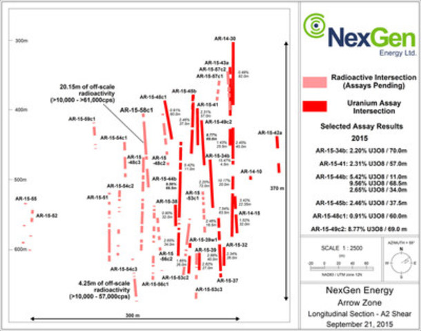
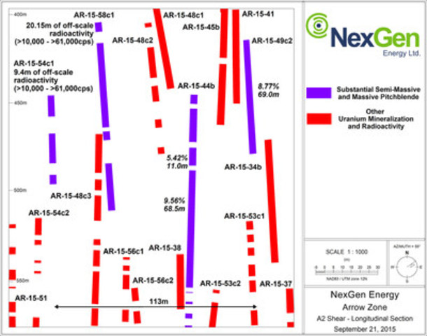
The reported results are highlighted by hole AR-15-58c1 which was drilled 53 and 80 m southwest from AR-15-44b and -49c2, respectively. Hole AR-15-58c1 intersected a higher grade sub-zone within the A2 core which has a strike length of 113 m that is characterized by substantial accumulations of dense massive and semi-massive pitchblende mineralization in drill holes AR-15-49c2, -44b, -58c1, and -54c1 (see Figure 3 and Table 1 for cps readings).
In addition, hole AR-15-58c1 has discovered a new zone of visible high-grade uranium mineralization in what has now been named the "A4 shear". The Arrow zone is currently comprised of four high-grade shear zones; A1, A2, A3 and A4 that are sub-parallel to each other in sequential order from northwest to southeast.
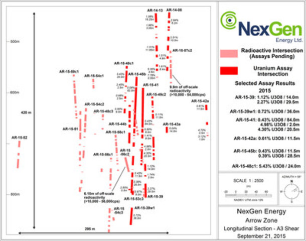
Further, drill holes AR-15-56c2 and -57c2 both intersected significant visible high-grade uranium mineralization in the A3 shear. The expanded five rig 30,000 m summer 2015 drill program continues with the Company focusing on further defining the area captured within holes AR-15-49c2, -44b, -58c1 and -54c1 as well as infilling the A2 through A4 southwest extensions at Arrow.
Highlights:
A2 Shear
AR-15-58c1 (53 m step-out up-dip and southwest from AR-15-44b) intersected 86.0 m of total composite mineralization including 20.25 m of off-scale radioactivity (>10,000 to >61,000 cps) within a 102.5 m section (422.5 to 525.0 m) in the A2 shear marked by substantial accumulations of dense massive and semi-massive pitchblende (see http://www.nexgenenergy.ca/s/photo-gallery.asp for photos of drill core).
- AR-15-54c3 (150 m step-out down-plunge southwest from AR-15-44b) intersected 36.0 m of total composite mineralization including 4.25 m of off-scale radioactivity (>10,000 to 57,000 cps) within a 89.5 m section (628.0 to 717.5 m) in the A2 shear.
Table 1: A2 High Grade Core Drill Hole Comparisons
|
|
|
|
|
|
AR-15-54c1
|
AR-15-58c1
|
AR-15-44b*
|
AR-15-49c2*
|
|
Total composite mineralization =
|
42.00 m
|
86.00 m
|
135.60 m
|
73.50 m
|
|
Total Off-scale (10,000 to 30,000 cps)** =
|
5.90 m
|
14.30 m
|
30.25 m
|
15.70 m
|
|
Total Off-scale (>30,000 to 61,000 cps)** =
|
3.00 m
|
3.85 m
|
7.75 m
|
5.20 m
|
|
Total Off-scale (>61,000 cps)** =
|
0.50 m
|
2.00 m
|
1.50 m
|
2.15 m
|
|
Continuous GT (Grade x Thickness) =
|
Assays
Pending
|
Assays
Pending
|
655
|
605
|
|
* radioactivity and assay results previously released
|
|
** minimum radioactivity using RS-125 gamma spectrometer
|
A3 Shear
- AR-15-57c2 (93 m step-out up-plunge and northeast from AR-14-41) intersected 48.0 m of total composite mineralization including 9.9 m of off-scale radioactivity (>10,000 – 54,000 cps) within a 93.0 m section (527.5 to 620.5 m) in the A3 shear.
- AR-15-56c2 (33 m step-out up-dip and southwest from AR-14-39) intersected 37.5 m of total composite mineralization including 5.65 m of off-scale radioactivity (>10,000 – 56,000 cps) within a 79.0 m section (746.0 to 825.0 m) in the A3 shear.
A4 Shear
- AR-15-58c1 intersected 47.5 m of total composite mineralization including 7.35 m of off-scale radioactivity (>10,000 - >61,000 cps) within a 150.0 m section (834.5 to 984.5 m) in the A4 shear.
- This hole represents the first the Company has drilled into the A4 shear which is situated parallel to the A3 shear and to the southeast.
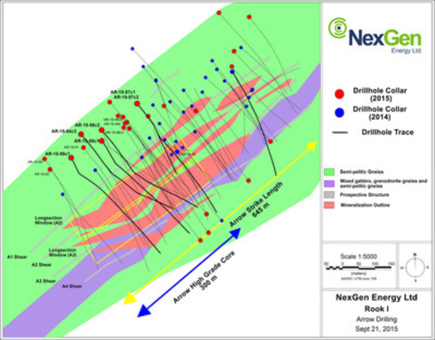
- The land-based and basement hosted Arrow zone currently covers an area of 645 m by 215 m with a vertical extent of mineralization commencing from 100 m to 920 m, and remains open in all directions and at depth;
- Five rigs continue to turn on the Arrow zone as part of the 2015 summer program recently expanded to 30,000 m;
- The Company has cash on hand of approximately C$23M
Garrett Ainsworth, NexGen's Vice-President, Exploration and Development, commented "Arrow remains resilient in delivering relentless continuity. Hole AR-15-58c1 has revealed a sub-vertical and gently southwest plunging higher grade body within the high grade A2 core that is characterized by significant accumulations of dense massive pitchblende (>61,000 cps). It is thus far delineated by holes AR-15-49c2, -44b, -58c1, and -54c1 with a strike length of 113 m. Further, the implications of discovering substantial high grade mineralization in the A4 is very positive for Arrow, as it reinforces the prospectivity to find additional mineralized shears further to the southeast of A4, and northwest of A1 which will be an objective of the winter 2016 program."
Leigh Curyer, Chief Executive Officer commented, "Even with employing a drilling methodology designed to systematically test Arrow, it continues to return outstanding results. The drilling program is still in the stage of broadly testing the area of mineralization and yet is regularly producing world class intercepts. The particularly encouraging factor amongst many, is the relatively wide distance between a number of holes that intersect substantial dense massive pitchblende. In addition, with the discovery of the A4 shear along with Bow and some highly prospective targets on the Derkson corridor, we are looking ahead eagerly to what the future holds not only for Arrow but for the Rook I property as a whole. With our cash balance of C$23 million we are fully funded through 2016. "
Drill hole locations, and the A2 and A3 long sections are shown in Figures 1 to 4, and Table 1 has a summary of the mineralized intervals.
Table 1: Arrow Zone Drill Hole Data
|
Drill Hole
|
Athabasca Group -
Basement
Unconformity Depth
(m)
|
Handheld Scintillometer Results (RS-120)
|
|
Hole ID
|
Azimuth
|
Dip
|
Total
Depth (m)
|
From (m)
|
To (m)
|
Width (m)
|
CPS Range
|
|
AR-15-54c3
|
140
|
-76
|
1060.00
|
109.00
|
628.00
|
630.00
|
2.00
|
<500 - 1900
|
|
|
|
|
|
642.50
|
643.00
|
0.50
|
<500 - 1100
|
|
|
|
|
|
649.50
|
650.50
|
1.00
|
<500 - 3500
|
|
|
|
|
|
654.50
|
655.50
|
1.00
|
<500 - 3000
|
|
|
|
|
|
658.50
|
685.50
|
27.00
|
<500 - 57000
|
|
|
|
|
|
692.00
|
693.00
|
1.00
|
<500 - 900
|
|
|
|
|
|
714.00
|
717.50
|
3.50
|
<500 - 900
|
|
|
|
|
|
783.00
|
786.00
|
3.00
|
<500 - 1400
|
|
|
|
|
|
857.00
|
858.00
|
1.00
|
<500 - 4000
|
|
|
|
|
|
866.00
|
866.50
|
0.50
|
<500 - 650
|
|
|
|
|
|
872.00
|
878.50
|
6.50
|
<500 - 8500
|
|
|
|
|
|
919.50
|
921.50
|
2.00
|
<500 - 1050
|
|
|
|
|
|
924.00
|
925.00
|
1.00
|
<500 - 3500
|
|
AR-15-56c2
|
139
|
-76.5
|
999.00
|
110.40
|
479.50
|
481.00
|
1.50
|
<500 - 1500
|
|
|
|
|
|
566.50
|
574.00
|
7.50
|
<500 - 52000
|
|
|
|
|
|
580.00
|
587.00
|
7.00
|
<500 - 40000
|
|
|
|
|
|
593.50
|
599.00
|
5.50
|
<500 - 2600
|
|
|
|
|
|
610.00
|
614.50
|
4.50
|
<500 - 1400
|
|
|
|
|
|
643.50
|
644.50
|
1.00
|
<500 - 8650
|
|
|
|
|
|
718.00
|
718.50
|
0.50
|
<500 - 1560
|
|
|
|
|
|
730.00
|
734.00
|
4.00
|
<500 - 810
|
|
|
|
|
|
746.00
|
778.00
|
32.00
|
<500 - 56000
|
|
|
|
|
|
782.00
|
782.50
|
0.50
|
<500 - 7400
|
|
|
|
|
|
793.00
|
793.50
|
0.50
|
<500 - 530
|
|
|
|
|
|
811.50
|
813.50
|
2.00
|
<500 - 2800
|
|
|
|
|
|
819.00
|
820.50
|
1.50
|
10000 - 56000
|
|
|
|
|
|
824.00
|
825.00
|
1.00
|
<500 - 20000
|
|
|
|
|
|
898.50
|
899.50
|
1.00
|
<500 - 14000
|
|
|
|
|
|
916.00
|
917.50
|
1.50
|
<500 - 38000
|
|
|
|
|
|
930.00
|
930.50
|
0.50
|
<500 - 750
|
|
|
|
|
|
937.50
|
939.50
|
2.00
|
<500 - 2100
|
|
AR-15-57c1
|
140
|
-73
|
468.00
|
109.30
|
382.00
|
390.00
|
8.00
|
<500 - 1500
|
|
|
|
|
|
397.00
|
404.50
|
7.50
|
<500 - 1600
|
|
|
|
|
|
410.00
|
416.50
|
6.50
|
<500 - 1500
|
|
|
|
|
|
440.50
|
447.50
|
7.00
|
<500 - 2000
|
|
|
|
|
|
453.00
|
460.00
|
7.00
|
<500 - 950
|
|
AR-15-57c2
|
140
|
-73
|
822.00
|
109.30
|
294.00
|
294.50
|
0.50
|
<500 - 515
|
|
|
|
|
|
329.00
|
329.50
|
0.50
|
<500 - 550
|
|
|
|
|
|
335.00
|
336.00
|
1.00
|
<500 - 560
|
|
|
|
|
|
357.00
|
378.00
|
21.00
|
<500 - 8500
|
|
|
|
|
|
381.50
|
400.00
|
18.50
|
<500 - 2410
|
|
|
|
|
|
403.50
|
418.00
|
14.50
|
<500 - 7800
|
|
|
|
|
|
448.50
|
449.50
|
1.00
|
<500 - 650
|
|
|
|
|
|
527.50
|
528.00
|
0.50
|
<500 - 1050
|
|
|
|
|
|
544.00
|
544.50
|
0.50
|
<500 - 515
|
|
|
|
|
|
549.00
|
554.00
|
5.00
|
<500 - 2200
|
|
|
|
|
|
561.50
|
564.00
|
2.50
|
<500 - 1300
|
|
|
|
|
|
569.00
|
575.50
|
6.50
|
<500 - 52000
|
|
|
|
|
|
578.00
|
587.00
|
9.00
|
<500 - 36000
|
|
|
|
|
|
589.25
|
610.00
|
20.75
|
<500 - 54000
|
|
|
|
|
|
612.75
|
613.00
|
0.25
|
3200 - 14000
|
|
|
|
|
|
617.50
|
620.50
|
3.00
|
<500 - 21000
|
|
|
|
|
|
633.00
|
633.50
|
0.50
|
<500 - 500
|
|
|
|
|
|
648.00
|
651.00
|
3.00
|
<500 - 6400
|
|
|
|
|
|
660.00
|
667.50
|
7.50
|
<500 - 33000
|
|
|
|
|
|
670.50
|
671.00
|
0.50
|
<500 - 1580
|
|
|
|
|
|
740.00
|
741.00
|
1.00
|
<500 - 1800
|
|
|
|
|
|
744.50
|
745.00
|
0.50
|
<500 - 550
|
|
AR-15-58c1
|
140
|
-73
|
1044.00
|
100.65
|
396.00
|
399.00
|
3.00
|
<500 - 620
|
|
|
|
|
|
411.00
|
419.00
|
8.00
|
<500 - 6000
|
|
|
|
|
|
422.50
|
475.50
|
53.00
|
<500 - >61000
|
|
|
|
|
|
478.00
|
483.00
|
5.00
|
<500 - 2300
|
|
|
|
|
|
497.00
|
525.00
|
28.00
|
<500 - >61000
|
|
|
|
|
|
543.50
|
545.00
|
1.50
|
<500 - 700
|
|
|
|
|
|
576.50
|
579.50
|
3.00
|
<500 - 570
|
|
|
|
|
|
624.00
|
624.50
|
0.50
|
<500 - 900
|
|
|
|
|
|
650.00
|
651.00
|
1.00
|
<500 - 600
|
|
|
|
|
|
677.00
|
677.50
|
0.50
|
<500 - 630
|
|
|
|
|
|
691.50
|
692.00
|
0.50
|
<500 - 600
|
|
|
|
|
|
706.50
|
712.00
|
5.50
|
<500 - 9200
|
|
|
|
|
|
715.00
|
718.50
|
3.50
|
<500 - 4600
|
|
|
|
|
|
721.00
|
730.00
|
9.00
|
<500 - 4000
|
|
|
|
|
|
732.50
|
744.50
|
12.00
|
<500 - 15000
|
|
|
|
|
|
747.50
|
749.00
|
1.50
|
<500 - 3700
|
|
|
|
|
|
754.50
|
763.00
|
8.50
|
<500 - 13000
|
|
|
|
|
|
765.50
|
767.50
|
2.00
|
<500 - 5500
|
|
|
|
|
|
778.50
|
781.00
|
2.50
|
<500 - 720
|
|
|
|
|
|
784.50
|
790.50
|
6.00
|
<500 - 2000
|
|
|
|
|
|
794.50
|
795.00
|
0.50
|
<500 - 600
|
|
|
|
|
|
806.00
|
806.50
|
0.50
|
<500 - 1100
|
|
|
|
|
|
819.50
|
820.00
|
0.50
|
<500 - 600
|
|
|
|
|
|
824.50
|
825.50
|
1.00
|
600 - 5300
|
|
|
|
|
|
831.50
|
832.00
|
0.50
|
<500 - 2700
|
|
|
|
|
|
834.50
|
846.50
|
12.00
|
<500 - 3100
|
|
|
|
|
|
858.50
|
859.00
|
0.50
|
<500 - 7400
|
|
|
|
|
|
863.50
|
868.00
|
4.50
|
<500 - 17000
|
|
|
|
|
|
875.50
|
880.00
|
4.50
|
<500 - >61000
|
|
|
|
|
|
882.50
|
883.00
|
0.50
|
<500 - 550
|
|
|
|
|
|
885.50
|
898.50
|
13.00
|
<500 - 55000
|
|
|
|
|
|
901.00
|
901.50
|
0.50
|
<500 - 550
|
|
|
|
|
|
909.50
|
915.00
|
5.50
|
<500 - 32000
|
|
|
|
|
|
918.00
|
918.50
|
0.50
|
<500 - 580
|
|
|
|
|
|
926.50
|
927.50
|
1.00
|
<500 - 800
|
|
|
|
|
|
939.00
|
943.50
|
4.50
|
<500 - 18500
|
|
|
|
|
|
984.00
|
984.50
|
0.50
|
<500 - 950
|
|
AR-15-59c1
|
150
|
-75
|
936.00
|
102.20
|
428.00
|
428.50
|
0.50
|
<500 - 650
|
|
|
|
|
|
431.50
|
432.50
|
1.00
|
<500 - 11500
|
|
|
|
|
|
438.00
|
451.50
|
13.50
|
<500 - 12500
|
|
|
|
|
|
465.00
|
466.00
|
1.00
|
<500 - 870
|
|
|
|
|
|
471.00
|
471.75
|
0.75
|
<500 - 49000
|
|
|
|
|
|
517.00
|
517.50
|
0.50
|
<500 - 550
|
|
|
|
|
|
540.00
|
540.50
|
0.50
|
<500 - 550
|
|
|
|
|
|
561.00
|
566.00
|
5.00
|
<500 - 8800
|
|
|
|
|
|
571.00
|
571.50
|
0.50
|
<500 - 580
|
|
|
|
|
|
586.50
|
587.00
|
0.50
|
<500 - 1050
|
|
|
|
|
|
589.50
|
593.50
|
4.00
|
<500 - 1550
|
|
|
|
|
|
602.50
|
606.00
|
3.50
|
<500 - 1050
|
|
|
|
|
|
608.50
|
630.50
|
22.00
|
<500 - 5100
|
|
|
|
|
|
634.50
|
651.50
|
17.00
|
<500 - 4000
|
|
|
|
|
|
656.50
|
660.00
|
3.50
|
<500 - 5800
|
|
|
|
|
|
666.50
|
668.00
|
1.50
|
<500 - 3100
|
|
|
|
|
|
671.50
|
677.00
|
5.50
|
<500 - 1800
|
|
|
|
|
|
680.00
|
683.00
|
3.00
|
<500 - 800
|
|
|
|
|
|
705.50
|
706.00
|
0.50
|
<500 - 610
|
|
|
|
|
|
738.00
|
741.50
|
3.50
|
<500 - 2200
|
|
|
|
|
|
754.50
|
755.00
|
0.50
|
<500 - 3500
|
|
|
|
|
|
778.00
|
788.50
|
10.50
|
<500 - 6700
|
|
|
|
|
|
792.50
|
793.50
|
1.00
|
<500 - 8800
|
|
|
|
|
|
801.00
|
803.00
|
2.00
|
<500 - 47000
|
|
|
|
|
|
818.00
|
818.60
|
0.60
|
<500 - 44000
|
|
|
|
|
|
824.00
|
826.40
|
2.40
|
<500 - 38000
|
|
|
|
|
|
832.50
|
833.50
|
1.00
|
<500 - 25000
|
|
|
|
|
|
846.00
|
848.30
|
2.30
|
<500 - 54000
|
|
|
|
|
|
851.50
|
852.50
|
1.00
|
<500 - 1800
|
|
|
|
|
|
855.50
|
856.50
|
1.00
|
<500 - 3100
|
|
|
|
|
|
874.50
|
875.30
|
0.80
|
<500 - 12500
|
Parameters:
- Maximum internal dilution 2.00 m downhole
- All depths and intervals are meters downhole
- "Anomalous" means >500 cps (counts per second) total count gamma readings by gamma scintillometer type RS-120
- "Off-scale" means >10,000 cps (counts per second) total count gamma readings by gamma scintillometer type RS-120
- Where "Min cps" is <500 cps, this refers to local low radiometric zones within the overall radioactive interval
Natural gamma radiation in drill core reported in this news release was measured in counts per second (cps) using a Radiation Solutions Inc. RS-120 gamma-ray scintillometer. The reader is cautioned that total count gamma readings may not be directly or uniformly related to uranium grades of the rock sample measured; they should be used only as a preliminary indication of the presence of radioactive minerals. All intersections are downhole. Core interval measurements and true thicknesses are yet to be determined.
Split core samples will be taken systematically, and intervals will be submitted to SRC Geoanalytical Laboratories (an SCC ISO/IEC 17025: 2005 Accredited Facility) of Saskatoon for analysis. All samples sent to SRC will be analyzed using ICP-MS for trace elements on the partial and total digestions, ICP-OES for major and minor elements on the total digestion, and fusion solution of boron by ICP-OES. Mineralized samples are analyzed for U3O8 by ICP-OES and select samples for gold by fire assay. Assay results will be released when received.
ARROW ZONE DRILLING
AR-15-54c3
Hole AR-15-54c3 was a directional hole that departed from pilot hole AR-15-54c2 at a depth of 352 m. It tested the A2 shear 80 m southwest of AR-15-39w1 (1.85% U3O8 over 26.0m in the A2 shear) and the A3 shear 75 m down-dip of AR-15-56c1 (8.35m of off-scale radioactivity in the A3 shear; assays pending). Directional drilling was initiated at 481 m. The A2 and A3 shears were intersected at inclinations of -71° and -73°, respectively.
Since the hole departed the pilot hole below the unconformity, no Athabasca Group sandstones were intersected. Basement lithologies consisted largely of semipelitic gneiss to granofel, and relatively narrow intervals of pelitic gneiss and mylonite (the A2 and A3 shears). The hole successfully intersected widespread weakly to strongly anomalous radioactivity within the A2 and A3 shears that was associated with semi-massive veins worm-rock style, chemical solution fronts, stringers, blebs and flecks of pitchblende. A total composite mineralization of 50.0 m including 4.25 m of off-scale radioactivity (>10,000 - 57,000 cps) was intersected within a 297.0 m section (628.0 to 925.0 m). In the A2 shear, 36.0m of composite mineralization including 4.25 m of off-scale radioactivity was intersected. In the A3 shear 11.0 m of composite mineralization was intersected. The hole was terminated at 1,060.0 m and represents significant growth to the high-grade portion of the A2 shear.
AR-15-56c2
Hole AR-15-56c2 was a directional hole that departed from pilot hole AR-15-56c1 at a depth of 274 m. It tested the A2 shear 41 m southwest of AR-15-53c2 (6.55 m of off-scale radioactivity in the A2 shear; assays pending) and the A3 shear 33 m up-plunge and southwest from AR-15-39 (2.27% U3O8 over 29.5 m in the A3 shear). Directional drilling was initiated at 331 m. The A2 and A3 shears were intersected at inclinations of -76° and -63°, respectively.
Since the hole departed the pilot hole below the unconformity, no Athabasca Group sandstones were intersected. Basement lithologies consisted largely of semipelitic gneiss to granofel, and relatively narrow intervals of pelitic gneiss and mylonite (the A2 through A4 shears). The hole successfully intersected widespread weakly to strongly anomalous radioactivity within the A2, A3 and A4 shears that was associated with semi-massive veins worm-rock style, chemical solution fronts, stringers, blebs and flecks of pitchblende. A total composite mineralization of 74.0 m including 7.45 m of off-scale radioactivity (>10,000 - 56,000 cps) was intersected within a 460.0 m section (479.5 to 939.5 m). In the A2 shear, 25.5 m of composite mineralization including 1.3 m of off-scale radioactivity was intersected. In the A3 shear, 37.5 m of composite mineralization including 5.65 m of off-scale radioactivity was intersected. In the A4 shear, 4.0 m of composite mineralization including 0.75 m of off-scale radioactivity was intersected. The hole was terminated at 999.0 m and represents significant growth to the high-grade portion of the A3 shear.
AR-15-57c1
Hole AR-15-57c1 was a directional hole collared at an angled orientation (-73°) to the southeast (140°). It tested the A2 shear 60 m up-plunge from AR-15-41 (2.31% U3O8 over 57.0 m in the A2 shear). Directional drilling was initiated at 202 m and the A2 shear was intersected at an inclination of -54°.
The hole intersected desilicified and bleached Athabasca Group sandstones between 99.0 m and the unconformity at 109.3 m. Basement lithologies consisted largely of semipelitic gneiss to granofel, and relatively narrow intervals of pelitic gneiss and mylonite (the A2 shear). Weakly to moderately anomalous radioactivity was intersected in the A2 shear. A total composite mineralization of 36.0 m was intersected within a 78.0 m section (382.0 to 460.0 m) before the hole was terminated at 468 m. The hole terminated immediately after the A2 shear to avoid twinning holes already planned for the A3 shear.
AR-15-57c2
Hole AR-15-57c2 was a directional hole that departed from pilot hole AR-15-57c1 at a depth of 264 m. It tested the thickness of the A2 shear in the vicinity of AR-15-30 (7.54% U3O8 over 63.5m in the A2 shear) and the A3 shear 93 m up-plunge to the northeast from AR-15-41 (4.30% U3O8 over 20.5m in the A3 shear). Directional drilling was initiated at 202m. The A2 and A3 shears were intersected at inclinations of -64° and -63°, respectively.
Since the hole departed the pilot hole below the unconformity, no Athabasca Group sandstones were intersected. Basement lithologies consisted largely of semipelitic gneiss to granofel, and relatively narrow intervals of pelitic gneiss and mylonite (the A2 through A4 shears). The hole successfully intersected widespread weakly to strongly anomalous radioactivity within the A2, A3 and A4 shears that was associated with semi-massive veins worm-rock style, chemical solution fronts, stringers, blebs and flecks of pitchblende. A total composite mineralization of 118.0 m including 10.2 m of off-scale radioactivity (>10,000 – 52,000 cps) was intersected within a 451.0 m section (294.0 to 745.0 m). In the A2 shear, 55.0 m of composite mineralization was intersected. In the A3 shear, 48.0 m of composite mineralization including 9.9 m of off-scale radioactivity was intersected. In the A4 shear, 12.5 m of composite mineralization including 0.3 m of off-scale radioactivity was intersected. The hole was terminated at 822.0 m and represents significant growth to the high-grade portion of the A3 shear.
AR-15-58c1
Hole AR-15-58c1 was a directional hole collared at an angled orientation (-75°) to the southeast (140°). It tested the A2 shear 53 m up-dip and to the southwest from AR-15-44b (11.55% U3O8 over 56.5 m in the A2 shear) and the A3 shear 103 m down-plunge to the southwest from AR-15-41. Directional drilling was initiated at 283 m. The A2 and A3 shears were both intersected at inclinations of -71°.
The hole intersected desilicified and bleached Athabasca Group sandstones between 93.1 m and the unconformity at 100.6 m. Basement lithologies consisted largely of semipelitic gneiss to granofel, and relatively narrow intervals of pelitic gneiss and mylonite (the A2 through A4 shears). The hole successfully intersected widespread weakly to strongly anomalous radioactivity within the A2, A3 and A4 shears that was associated with semi-massive to massive veins worm-rock style, chemical solution fronts, stringers, blebs and flecks of pitchblende. Mineralization was particularly strong in both the A2 and A4 shears being where marked by local dense accumulations of massive pitchblende. A total composite mineralization of 205.0 m including 27.85 m of off-scale radioactivity (>10,000 – >61,000 cps) was intersected within a 588.5 m section (396.0 to 984.5 m). In the A2 shear, 86.0 m of composite mineralization including 20.15 m of off-scale radioactivity was intersected. In the A3 shear, 53.0 m of composite mineralization including 0.35 m of off-scale radioactivity was intersected. In the A4 shear, 47.5 m of composite mineralization including 7.35 m of off-scale radioactivity was intersected. The hole was terminated at 1,044 m. It represents both the identification of similar accumulations of high grade massive pitchblende mineralization as observed in hole AR-15-49c2 and -44b within the A2 shear, and the discovery of a significant new zone of high-grade mineralization in the A4 shear.
AR-15-59c1
Hole AR-15-59c1 was a directional hole collared at an angled orientation (-75°) to the southeast (150° azimuth). It tested the A2 shear 52 m up-plunge to the southwest from AR-15-54c1 (9.4 m of off-scale radioactivity in the A2 shear; assays pending) and the A3 shear 135 m up-dip from AR-15-51 (6.45 m of off-scale radioactivity in the A3 shear; assays pending). Directional drilling was initiated at 157 m. The A2 and A3 shears were intersected at inclinations of -68° and -67°, respectively.
The hole intersected desilicified and bleached Athabasca Group sandstones between 99.0 m and the unconformity at 102.2 m. Basement lithologies consisted largely of semipelitic gneiss to granofel, and relatively narrow intervals of pelitic gneiss and mylonite (the A2 through A4 shears). The hole successfully intersected widespread weakly to strongly anomalous radioactivity within the A2, A3 and A4 shears that was associated with semi-massive veins worm-rock style, chemical solution fronts, stringers, blebs and flecks of pitchblende. A total composite mineralization of 110.85 m including 3.75 m of off-scale radioactivity (>10,000 – 54,000 cps) was intersected within a 447.5 m section (428.0 to 875.5 m). In the A2 shear, 16.75 m of composite mineralization including 0.55 m of off-scale radioactivity was intersected. In the A3 shear, 66.0 m of composite mineralization was intersected. In the A4 shear, 27.1 m of composite mineralization including 3.2 m of off-scale radioactivity was intersected. The hole was terminated at 936 m growth to the high-grade portion of the A4 shear.
NORTHEAST OF BOW DISCOVERY DRILLING
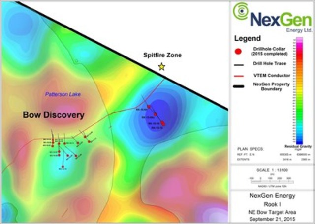
The Bow discovery which is located 3.7 km along strike to the northeast from Arrow was first tested by the Company in the winter of 2014. It consists of a zone of highly deformed and moderately south dipping (~60°) package of pelitic rocks with semipelitic hanging wall and footwall, which is underlain by an intrusive assemblage. Drill hole BO-15-10 intersected 9.5 m at 0.2% U3O8 between 204.5 m and 214.0 m (see press release dated June 30, 2015).
Drill holes RK-15-64, -66a, -69 and -72 were collared as a fence in an area roughly 750 m northeast along strike of the Bow discovery to test a prominent broad circular gravity low flanking a VTEM conductor. All four holes were collared at angled orientations (-70° and -73°) to the northwest (320°). In total 1,974 m of drilling were completed. Drill hole locations are shown in Figure 5.
All four drill holes intersected heavily bleached and desilicified Athabasca Group sandstones. Basement lithologies consisted of a folded, moderately south dipping (~30-60°) package of semipelitic gneiss, felsic to mafic orthogneiss and relatively narrow intervals of graphitic mylonite and cataclasite (the conductor source). Hydrothermal alteration facies intersected commonly included chlorite, hematite and clay. Dravite breccia veins, similar to those found at Arrow 4.5 km along strike to the southwest, were also intersected locally and in association with anomalous uraniferous radioactivity.
Weak uranium mineralization was intersected in RK-15-69 in close association with mylonite and dravite breccia veining. Assays returned 2.5 m at 0.05% U3O8 between 332.0 m and 334.5 m. Down-hole gamma surveys (2PGA-1000 probe) also measured anomalous radioactivity in drill holes RK-15-64, -66a, and -72 of up to 1,239 cps (>500 cps is anomalous). These radioactive peaks were identified as being sourced from the presence thorium.
Drilling in the area northeast of Bow confirmed the presence of a prospective uranium bearing structure. Further drilling was prematurely terminated due to the threat of a forest fire, which was done in accordance with established company standard operating procedures. The fire was extinguished naturally before advancing through the area. The Company remains encouraged on the potential of this portion of the Patterson corridor, and additional drilling is warranted for winter 2016.
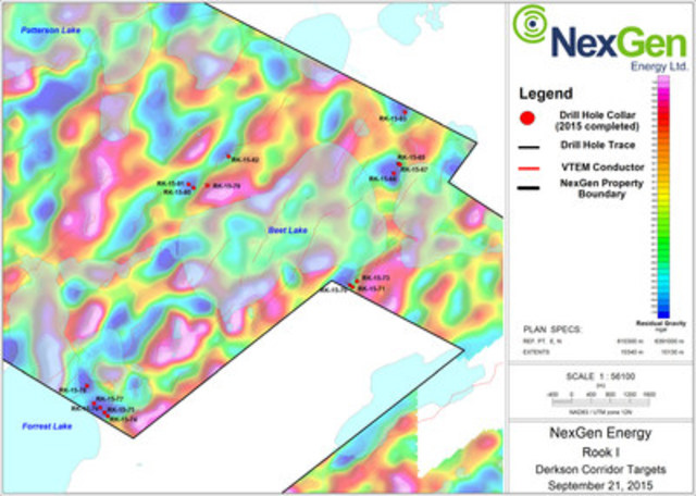
DERKSON CORRIDOR DRILLING
A further 16 holes were completed on the Derkson conductor corridor which is known to host anomalous uranium concentrations discovered by past operators (DER-04 intersected 0.2% U over 2.5m, 1978). In total 4,670 m of drilling was completed in the area. All holes were collared at angled orientations (-70°) to the northwest (298° to 345°). Drill hole locations are shown in Figure 6.
Holes RK-15-65, -67 and -68 were collared to test the terminus of a VTEM conductor flanked by a prominent broad circular gravity low. No Athabasca Group sandstones were intersected. Basement lithologies consisted of a series of weakly clay, chlorite and hematite altered, and locally graphitic semipelitic gneiss and orthogneiss of variable composition. The source of the VTEM anomaly was identified in RK-15-65 and -67. It consisted of a broad package of prospective graphitic semipelitic gneiss. Anomalous radioactivity of up to 510 cps (2PGA-1000 probe) was intersected in RK-15-65 and -68. Spectrometer analysis (handheld RS-125) showed that the radioactivity was due to the presence thorium.
Holes RK-15-70, -71 and -73 were collared to test the terminus of a folded VTEM conductor flanked by a prominent broad circular gravity low. No Athabasca Group sandstones were intersected. Basement lithologies consisted largely of semipelitic gneiss and orthogneiss of variable composition. The source of the VTEM conductor, which was intersected in RK-15-73 was shown to be moderately graphitic pelitic gneiss. Variable clay alteration was intersected in a shear zone in all three holes. No anomalous radioactivity was intersected.
Holes RK-15-74 through -78, were collared as a fence to test a series of VTEM conductor breaks in a broad gravity low. No Athabasca Group sandstones were intersected. Basement lithologies consisted largely of locally graphitic semipelitic to pelitic gneiss and orthogneiss of variable composition. Anomalous radioactivity of up to 2,090 cps (2PGA-1000 probe) was intersected in RK-15-75 and -76. Spectrometer analysis (handheld RS-125) showed that the radioactivity was due to the presence thorium.
Holes RK-15-79 through -82 were designed to test VTEM conductors and conductor breaks associated with broad circular gravity lows. No Athabasca Group sandstones were intersected. Basement lithologies consisted largely of semipelitic gneiss and orthogneiss of variable composition. Strong clay and chlorite alteration were observed locally, and often in association with both brittle and ductile deformation. Anomalous radioactivity of up to 831 cps (2PGA-1000 probe) was intersected in RK-15-79, -80 and -81. Spectrometer analysis (handheld RS-125) showed that the radioactivity was due to the presence thorium.
Hole RK-15-83 was designed to test VTEM conductor flanking a broad circular gravity low. The hole intersected moderately to strongly bleached Athabasca Group sandstones between 57.9 m and the unconformity at 71.2 m. Basement lithologies consisted of consisted of a broad package of locally graphitic semipelitic gneiss which hosted a highly prospective graphitic mylonite. Orthogneiss of felsic to intermediate composition was intersected both above and below the semipelitic gneiss. Broad clay, chlorite and hematite alteration were observed throughout the basement. Anomalous radioactivity of up to 623 cps (2PGA-1000 probe) was intersected in RK-15-82. Spectrometer analysis (handheld RS-125) showed that the radioactivity was due to the presence thorium.
The Company also announces that it has granted 750,000 stock options to new employees and consultants in accordance with its stock option plan. The options are priced at $0.62 for a term of five years.
About NexGen
NexGen is a British Columbia corporation with a focus on the acquisition, exploration and development of Canadian uranium projects. NexGen has a highly experienced team of uranium industry professionals with a successful track record in the discovery of world class uranium deposits and in developing projects through discovery to production.
NexGen is well funded and owns a portfolio of highly prospective uranium exploration assets in the Athabasca Basin, Saskatchewan, Canada, including a 100% interest in Rook I, location of the Arrow Discovery in February 2014 and Bow Discovery in March 2015.
The technical information in this news release has been prepared in accordance with the Canadian regulatory requirements set out in National Instrument 43-101 and reviewed on behalf of NexGen Energy Ltd., by Garrett Ainsworth, P.Geo., Vice President – Exploration & Development, a qualified person.
Leigh Curyer,
Chief Executive Officer
NexGen Energy Ltd.
+1 604 428 4112
lcuryer@nexgenenergy.ca
www.nexgenenergy.ca
The TSXV has neither approved nor disapproved the contents of this press release. Neither the TSXV nor its Regulation Services Provider (as that term is defined in the policies of the TSXV) accepts responsibility for the adequacy or accuracy of this release.
Forward-Looking Information
This news release contains "forward-looking information" within the meaning of applicable Canadian securities laws. Generally, but not always, forward looking information is identifiable by the use of words such as "will" and planned" and similar expressions. Forward-looking information is based on the then current expectations, beliefs, assumptions, estimates and forecasts about the Company's business and the industry and markets in which it operates. Such information is not a guarantee of future performance and undue reliance should not be placed on forward-looking information. Assumptions and factors underlying the Company's expectations regarding forward-looking information contained herein include, among others: that general business and economic conditions will not change in a material adverse manner; that financing will be available if and when needed on reasonable terms; that the Company's current exploration activities can be achieved and that its other corporate activities will proceed as expected; that third party contractors, equipment and supplies and governmental and other approvals required to conduct the Company's planned exploration activities will be available on reasonable terms and in a timely manner.
Although the assumptions made by the Company in providing forward looking information are considered reasonable by management at the time the forward-looking information is given, there can be no assurance that such assumptions will prove to be accurate. Forward-looking information also involves known and unknown risks and uncertainties and other factors, which may cause actual events or results in future periods to differ materially from any projections of future events or results expressed or implied by such forward-looking information, including, among others: risks related to the availability of financing on commercially reasonable terms and the expected use of the proceeds; changes in the market; potential downturns in economic conditions; industry conditions; actual results of exploration activities being different than anticipated; changes in exploration programs based upon results of exploration; future prices of metal; availability of third party contractors; availability of equipment and supplies; failure of equipment to operate as anticipated; accidents, effects of weather and other natural phenomena and other risks associated with the mineral exploration industry; environmental risks; changes in laws and regulations; community relations; and delays in obtaining governmental or other approvals or financing. There can be no assurance that forward-looking information will prove to be accurate, as actual results and future events could differ materially from those anticipated, estimated or intended. NexGen undertakes no obligation to update or reissue forward-looking information as a result of new information or events except as required by applicable securities laws. The reader is cautioned not to place undue reliance on forward-looking information.
SOURCE NexGen Energy Ltd.
")
")
")
")
")
Image with caption: "Figure 1: Arrow Zone Drill Hole Locations (CNW Group/NexGen Energy Ltd.)". Image available at: http://photos.newswire.ca/images/download/20150922_C6442_PHOTO_EN_502968.jpg
Image with caption: "Figure 2: A2 Mineralized Shear Long Section (CNW Group/NexGen Energy Ltd.)". Image available at: http://photos.newswire.ca/images/download/20150922_C6442_PHOTO_EN_502938.jpg
Image with caption: "Figure 3: A2 Mineralized Shear Long Section Zoom In (CNW Group/NexGen Energy Ltd.)". Image available at: http://photos.newswire.ca/images/download/20150922_C6442_PHOTO_EN_502940.jpg
Image with caption: "Figure 4: A3 Mineralized Shear Long Section (CNW Group/NexGen Energy Ltd.)". Image available at: http://photos.newswire.ca/images/download/20150922_C6442_PHOTO_EN_502942.jpg
Image with caption: "Figure 5: Northeast of Bow Discovery Drill Hole Locations (CNW Group/NexGen Energy Ltd.)". Image available at: http://photos.newswire.ca/images/download/20150922_C6442_PHOTO_EN_502944.jpg
Image with caption: "Figure 6: Derkson Conductor Corridor Drill Hole Locations (CNW Group/NexGen Energy Ltd.)". Image available at: http://photos.newswire.ca/images/download/20150922_C6442_PHOTO_EN_502946.jpg

Kin Communications, Tel: 604 684 6730, Toll free 1 866 684 6730, Email: nxe@kincommunications.com, Website: http://www.nexgenenergy.caCopyright CNW Group 2015


