According to the latest market study released by Technavio,
the global aerial imaging market is expected to grow at a CAGR of almost
16% during the predicted period.
This press release features multimedia. View the full release here:
http://www.businesswire.com/news/home/20171011005757/en/
Technavio has published a new report on the global aerial imaging market from 2017-2021. (Graphic: Business Wire)
This research report titled ‘Global
Aerial Imaging Market 2017-2021’ provides an in-depth analysis of
the market in terms of revenue and emerging market trends. This market
research report also includes up to date analysis and forecasts for
various market segments and all geographical regions.
During 2017-2019, the market is expected to constantly grow owing to the
increased demand for aerial imagery for precision agriculture. Aerial
imagery provides precision agriculture solutions for farming operations
throughout the process. It helps leverage aerial imaging technology to
operate efficiently, save costs, and improve performance and
productivity of the crop. It increases efficiency by pre-determining
locations for land sampling based on real-time conditions. It also
provides a comprehensive view of fields not visible from roads, paths,
and vehicles.
This report is available at a USD 1,000 discount for a limited time
only: View
market snapshot before purchasing
Buy 1 Technavio report and get the second for 50% off. Buy 2
Technavio reports and get the third for free.
Technavio’s analysts categorize the global aerial
imaging market into seven major segments by end user. They are:
-
Oil and gas
-
Infrastructure and buildings
-
Mining
-
Sustainable energy
-
Public sector
-
Forestry and agriculture
-
Military and defense
Looking for more information on this market? Request
a free sample report
Technavio’s sample reports are free of charge and contain multiple
sections of the report including the market size and forecast, drivers,
challenges, trends, and more.
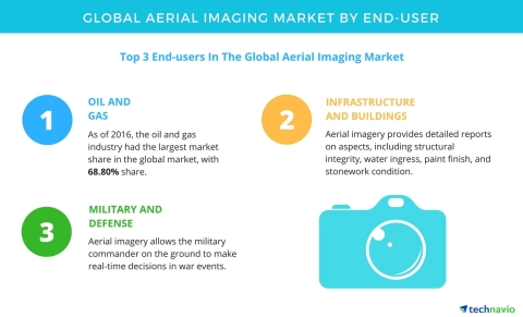
The top three end-user segments of the global aerial imaging market are
discussed below:
Oil and gas
The oil and gas market share is slowly being replaced by gas and
renewable energy sources because of the rapid depletion of non-renewable
energy sources. The oil and gas industry still have to meet the
demand-supply gap in addition to contending increased rates of depletion
of producing reservoirs. Aerial imagery provides benefits, including
field surveying and exploration of resources. Complete understanding of
geospatial landscapes helps in successful oil and gas production.
According to Raghu Raj Singh, a lead IT
professional services research analyst from Technavio, “Drones
with the latest technology and software produce aerial imagery to
maximize field productivity. Accurate GIS data management and survey
plant exhibits allow the oil and gas industry to mobilize and deploy
surveying assets for the large projects in a timely manner. Aerial
imagery provides comprehensive high accurate surveying and mapping
benefits for the oil and gas industry.”
Infrastructure and buildings
Aerial imagery offers advanced preventative maintenance services with
its high-resolution video-based surveys of buildings, towers, bridges,
and other large structures. Aerial imagery provides detailed reports on
aspects, including structural integrity, water ingress, paint finish,
and stonework condition. This information is mostly useful for critical
infrastructure protection and planning and acts as a resource in
disaster preparedness, response, and relief activity.
“Site-specific imaging assures customized coverage to meet planning
and infrastructure requirements. In March 2017, an app named Project
Sunroof created by Google can track buildings in the US that are solar
viable. The app can calculate the amount of sun hitting the roof through
3D models derived from aerial imagery,” says Raghu.
Military and defense
The major reason for the growth of the aerial imaging market by military
and defense is that the aerial imagery allows the military commander on
the ground to make real-time decisions in war events. It provides ground
surveys to assess the war situations with high accuracy. An important
driver that is to be considered is the increased spending by the US and
Canadian governments on the military.
An increase in military expenditure is necessary to purchase military
equipment, weapons systems, aircraft, navy vessels, and tanks. These
amounts will also be spent on acquiring the latest applications such as
military reconnaissance and intelligence-gathering applications. It
helps gather military intelligence or information about terrorist
activities.
The top vendors highlighted by Technavio’s research analysts in this
report are:
-
Cooper Aerial
-
Fugro
-
Kucera International
-
BLOMASA
Browse Related Reports:
About Technavio
Technavio
is a leading global technology research and advisory company. Their
research and analysis focuses on emerging market trends and provides
actionable insights to help businesses identify market opportunities and
develop effective strategies to optimize their market positions.
With over 500 specialized analysts, Technavio’s report library consists
of more than 10,000 reports and counting, covering 800 technologies,
spanning across 50 countries. Their client base consists of enterprises
of all sizes, including more than 100 Fortune 500 companies. This
growing client base relies on Technavio’s comprehensive coverage,
extensive research, and actionable market insights to identify
opportunities in existing and potential markets and assess their
competitive positions within changing market scenarios.
If you are interested in more information, please contact our media team
at media@technavio.com.

View source version on businesswire.com: http://www.businesswire.com/news/home/20171011005757/en/
Copyright Business Wire 2017