")
VANCOUVER, March 15, 2016 /CNW/ - NexGen Energy Ltd. ("NexGen" or the "Company") (TSXV:NXE, OTCQX:NXGEF) is pleased to announce results from nine angled drill holes from our ongoing 30,000 m winter 2016 drilling program on our 100% owned Rook I Property, Athabasca Basin, Saskatchewan.
Hole AR-16-75, a step-out hole 170m to the southwest along strike from Arrow intersected 39.5 m of total composite mineralization in the A3 and A4 shears, confirming Arrow remains open in all directions and at depth. This hole has extended the total strike length of mineralization at Arrow from 670 m to 840 m.
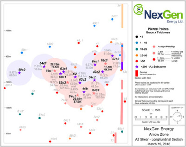
In addition, within the higher grade A2 sub-zone (the "Sub-Zone"), three holes have intersected extensive visible uranium mineralization. Holes AR-16-74c1, -76c1 and -78c1 all encountered intense radioactivity in the Sub-Zone marked by dense accumulations of semi-massive to massive pitchblende. Highlighting these results is hole AR-16-76c1, which intersected 5.25 m of minimum-greater-than-61,000 cps radioactivity, 3.5 m of which was continuous.
Highlights:
All nine holes reported in this news release have returned significant mineralization.
Southwest Extension:
- AR-16-75 (170 m southwest from the Arrow deposit) intersected 39.5 m of total composite mineralization (<500 – 4800 cps) within a 171.0 m section (750.0 to 921.0 m) in the A3 and A4 shears.
A2 Shear:
- AR-16-76c1 (70 m up-dip and southwest from AR-15-44b) intersected 73.5 m of total composite mineralization including 22.75 m of total composite off-scale radioactivity (10,000 - >61,000 cps) within a 107.0 m section (417.0 to 524.0 m) including 5.25 m of composite mineralization measuring a minimum >61,000 cps in the Sub-Zone.
- AR-16-74c1 (14 m down-dip and southwest of AR-15-44b) intersected 87.5 m of total composite mineralization including 22.35 m of total composite off-scale radioactivity (10,000 - >61,000 cps) within a 149.5 m section (491.0 to 640.5 m) in the Sub-Zone.
- AR-16-78c1 (69 m up-dip and northeast of AR-15-44b) intersected 64.0 m of total composite mineralization including 17.1 m of total composite off-scale radioactivity (10,000 - >61,000 cps) within a 95.0 m section (396.5 to 491.5 m) including 2.50 m of composite mineralization measuring a minimum >61,000 cps in the Sub-Zone.
- AR-16-72c2 (60 m down-dip and northeast of AR-15-44b) intersected 93.0 m of total composite mineralization including 9.15 m of total composite off-scale radioactivity (10,000 - >61,000 cps) within a 260.5 m section (438.5 to 699.0 m) in the A2 shear.
Table 1: Higher Grade A2 Sub-Zone Drill Hole Comparison
|
2015
|
AR-15-
59c22
|
AR-15-
54c12
|
AR-15-
58c12
|
AR-15-
622
|
AR-15-
44b2
|
AR-15-
49c22
|
AR-15-
57c32
|
|
Total composite mineralization =
|
75.50 m
|
42.00 m
|
86.00 m
|
143.00 m
|
135.60 m
|
73.50 m
|
62.50 m
|
|
Total Off-scale (>10,000 to 29,999 cps)3 =
|
11.40 m
|
5.90 m
|
14.30 m
|
17.75 m
|
30.25 m
|
15.70 m
|
4.40 m
|
|
Total Off-scale (>30,000 to 60,999 cps)3 =
|
4.50 m
|
3.00 m
|
3.85 m
|
10.60 m
|
7.75 m
|
5.20 m
|
2.50 m
|
|
Total Off-scale (>61,000 cps)3 =
|
1.00 m
|
0.50 m
|
2.00 m
|
2.00 m
|
1.50 m
|
2.15 m
|
1.80 m
|
|
Continuous GT (Grade x Thickness) =
|
371
|
277
|
200 and
345
|
787
|
655
|
605
|
319
|
|
2016
|
AR-16-
76c1
|
AR-16-
63c12
|
AR-16-
63c31
|
AR-16-
74c1
|
AR-16-
63c22
|
AR-16-
64c31
|
AR-16-
64c22
|
AR-16-
64c12
|
AR-16-
78c1
|
|
Total composite mineralization =
|
73.50 m
|
55.50 m
|
147.00 m
|
88.00 m
|
138.00 m
|
102.00 m
|
76.00 m
|
74.0 m
|
64.00 m
|
|
Total Off-scale (>10,000 to 29,999 cps)3 =
|
14.75 m
|
6.85 m
|
22.10 m
|
21.2 m
|
17.10 m
|
18.75 m
|
15.95 m
|
10.30 m
|
11.60 m
|
|
Total Off-scale (>30,000 to 60,999 cps)3 =
|
2.75 m
|
0.50 m
|
3.00 m
|
1.15 m
|
9.90 m
|
2.50 m
|
4.70 m
|
3.70 m
|
3.00 m
|
|
Total Off-scale (>61,000 cps)3 =
|
5.25 m
|
0.00 m
|
0.50 m
|
0.00 m
|
13.85 m
|
0.00 m
|
5.50 m
|
0.00 m
|
2.50 m
|
|
Continuous GT (Grade x Thickness) =
|
Assays
Pending
|
203
|
Assays
Pending
|
Assays
Pending
|
638 and
604
|
Assays
Pending
|
541
|
338
|
Assays
Pending
|
|
1 radioactivity results previously released
|
|
2 radioactivity and assays results previously released
|
|
3 minimum radioactivity using RS-120 gamma spectrometer
|
|
Arrow, Activities & Financial
-
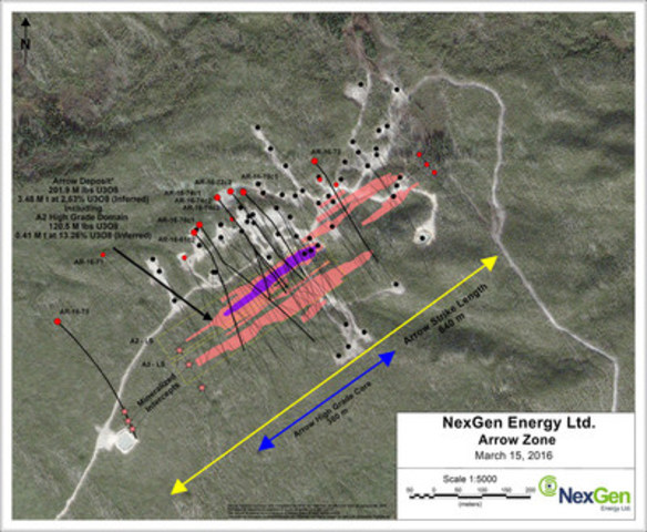
The land-based and basement hosted Arrow zone currently covers an area of 840 m by 235 m with a vertical extent of mineralization commencing from 100 m to 920 m, and remains open in all directions and at depth.
-
The winter 2016 program comprising 30,000 m of drilling continues with six drill rigs active.
-
The Company remains on track for release of an updated NI 43-101 resource estimate on the Arrow Deposit due in the second half of 2016
-
The Company has cash on hand of $31M.
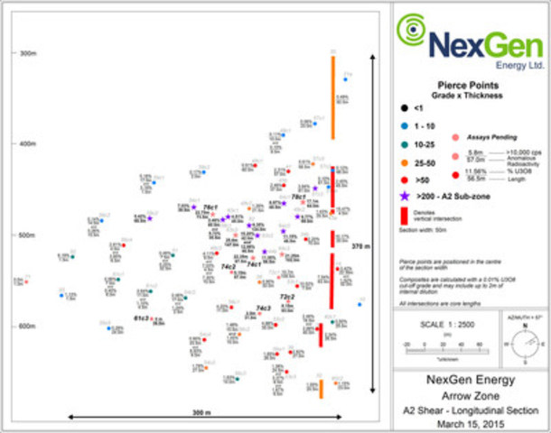
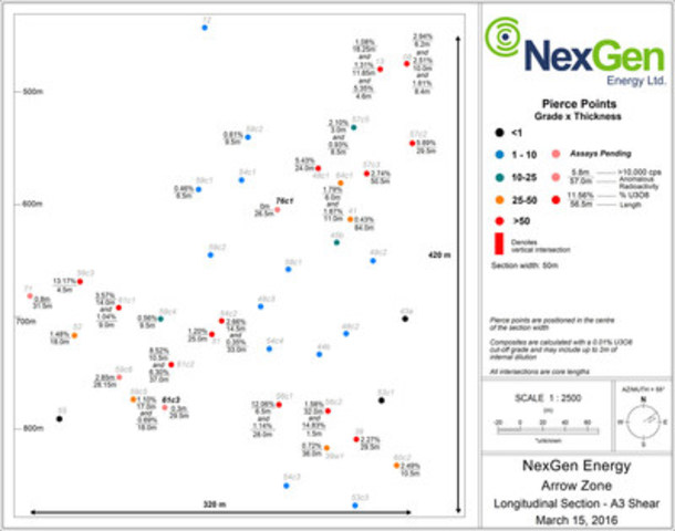
Drill hole locations, the Sub-Zone, and the A2 and A3 long sections are shown in Figures 1 to 4. Table 2 has a summary of the mineralized intervals.
Garrett Ainsworth, Vice-President, Exploration and Development, commented: "As shown with this latest batch of results, closer spaced drilling within the Arrow deposit is confirming and exceeding our expectations in terms of continuity of grades and widths. Testing 170 m southwest of the Arrow deposit has opened up an exciting new strike extent that we plan on aggressively following up on."
Leigh Curyer, Chief Executive Officer, commented: "Arrow continues to prove itself as a truly unique asset and one that keeps exceeding our expectations. Hole -75 which has extended the area of known mineralization by 170 m and infill drilling continues to intersect better mineralization than encountered in the best holes from 2015; this winter 2016 program continues to be our best to date."
Table 2: Arrow Zone Drill Hole Data
|
Drill Hole
|
Athabasca
Group -
Basement
Unconformity
Depth (m)
|
Handheld Scintillometer Results (RS-120)
|
|
Hole ID
|
Azimuth
|
Dip
|
Total
Depth
(m)
|
From (m)
|
To (m)
|
Width (m)
|
CPS Range
|
|
AR-16-61c3
|
140
|
-74
|
921.00
|
110.30
|
526.00
|
526.50
|
0.50
|
<500 - 1100
|
|
549.00
|
552.50
|
3.50
|
<500 - 4120
|
|
558.00
|
573.50
|
15.50
|
<500 - 2800
|
|
585.50
|
591.50
|
6.00
|
<500 - 1100
|
|
645.00
|
645.50
|
0.50
|
<500 - 1800
|
|
649.50
|
651.00
|
1.50
|
<500 - 2000
|
|
672.00
|
677.50
|
5.50
|
<500 - 3800
|
|
688.00
|
694.50
|
6.50
|
<500 - 5800
|
|
718.00
|
719.50
|
1.50
|
<500 - 2500
|
|
740.00
|
740.50
|
0.50
|
<500 - 1100
|
|
761.50
|
771.00
|
9.50
|
<500 - 1800
|
|
818.50
|
819.00
|
0.50
|
<500 - 510
|
|
823.50
|
833.00
|
9.50
|
<500 - 16000
|
|
836.50
|
839.00
|
2.50
|
<500 - 2600
|
|
844.50
|
849.50
|
5.00
|
<500 - 1300
|
|
889.50
|
890.00
|
0.50
|
<500 - 850
|
|
AR-16-72c2
|
145
|
-70
|
669
|
107.75
|
438.50
|
439.00
|
0.50
|
<500 - 820
|
|
509.00
|
510.50
|
1.50
|
<500 - 1550
|
|
519.00
|
520.00
|
1.00
|
<500 - 1500
|
|
541.50
|
543.50
|
2.00
|
<500 - 800
|
|
546.00
|
547.00
|
1.00
|
<500 - 4100
|
|
550.50
|
560.00
|
9.50
|
<500 - 28000
|
|
565.00
|
576.50
|
11.50
|
<500 - 13000
|
|
579.00
|
587.50
|
8.50
|
<500 - >61000
|
|
591.00
|
600.50
|
9.50
|
<500 - >61000
|
|
604.00
|
604.50
|
0.50
|
<500 - 6700
|
|
609.00
|
609.50
|
0.50
|
<500 - 29000
|
|
614.50
|
632.00
|
17.50
|
<500 - 21000
|
|
634.50
|
638.50
|
4.00
|
<500 - 2000
|
|
656.50
|
670.50
|
14.00
|
<500 - 7150
|
|
674.50
|
684.00
|
9.50
|
<500 - >61000
|
|
697.00
|
699.00
|
2.00
|
<500 - 1100
|
|
AR-16-73
|
145
|
-70
|
699.00
|
114.00
|
162.00
|
162.50
|
0.50
|
<500 - 800
|
|
221.00
|
229.00
|
8.00
|
<500 - 1900
|
|
231.50
|
232.50
|
1.00
|
<500 - 650
|
|
236.50
|
240.00
|
3.50
|
<500 - 4800
|
|
243.50
|
246.50
|
3.00
|
<500 - 2400
|
|
251.50
|
257.00
|
5.50
|
<500 - 12000
|
|
259.50
|
260.50
|
1.00
|
<500 - 850
|
|
264.50
|
271.50
|
7.00
|
<500 - 13000
|
|
287.00
|
289.00
|
2.00
|
<500 - 750
|
|
293.00
|
295.00
|
2.00
|
<500 - 770
|
|
323.50
|
325.50
|
2.00
|
<500 - 700
|
|
330.00
|
330.50
|
0.50
|
<500 - 1000
|
|
346.00
|
348.00
|
2.00
|
<500 - 1100
|
|
363.00
|
370.00
|
7.00
|
<500 - 1400
|
|
373.50
|
378.00
|
4.50
|
<500 - 1000
|
|
421.00
|
427.00
|
6.00
|
<500 - 1300
|
|
433.50
|
444.50
|
11.00
|
<500 - 1200
|
|
463.00
|
468.50
|
5.50
|
<500 - 1000
|
|
481.50
|
482.00
|
0.50
|
<500 - 500
|
|
495.00
|
495.50
|
0.50
|
<500 - 500
|
|
498.00
|
498.50
|
0.50
|
<500 - 500
|
|
527.00
|
532.00
|
5.00
|
<500 - 700
|
|
546.50
|
547.50
|
1.00
|
<500 - 800
|
|
554.00
|
558.00
|
4.00
|
<500 - 1000
|
|
565.50
|
567.50
|
2.00
|
<500 - 2000
|
|
572.00
|
577.00
|
5.00
|
<500 - 2400
|
|
579.50
|
583.00
|
3.50
|
<500 - 8000
|
|
586.00
|
593.00
|
7.00
|
<500 - 5600
|
|
602.50
|
604.00
|
1.50
|
<500 - 27000
|
|
613.00
|
613.50
|
0.50
|
600 - 12000
|
|
622.50
|
623.00
|
0.50
|
<500 - 630
|
|
625.50
|
627.50
|
2.00
|
<500 - 17000
|
|
AR-16-74c1
|
131
|
-69
|
648.00
|
113.80
|
175.00
|
175.50
|
0.50
|
<500 - 540
|
|
491.00
|
495.50
|
4.50
|
<500 - 43000
|
|
513.00
|
516.50
|
3.50
|
<500 - 48000
|
|
520.50
|
522.00
|
1.50
|
<500 - 2200
|
|
526.50
|
527.00
|
0.50
|
<500 - 1700
|
|
532.50
|
579.50
|
47.00
|
<500 - >61000
|
|
584.50
|
585.50
|
1.00
|
<500 - 28000
|
|
589.00
|
604.00
|
15.00
|
<500 - 59000
|
|
607.50
|
618.00
|
10.50
|
<500 - 11000
|
|
621.50
|
622.50
|
1.00
|
<500 - 3900
|
|
634.50
|
636.50
|
2.00
|
<500 - 1800
|
|
639.50
|
640.50
|
1.00
|
<500 - 950
|
|
AR-16-74c2
|
131
|
-69
|
663.00
|
113.80
|
512.50
|
514.00
|
1.50
|
<500 - 2500
|
|
524.00
|
529.00
|
5.00
|
<500 - 3800
|
|
531.50
|
534.50
|
3.00
|
<500 - 950
|
|
541.00
|
545.50
|
4.50
|
<500 - 34000
|
|
560.50
|
572.50
|
12.00
|
<500 - >61000
|
|
576.00
|
581.00
|
5.00
|
<500 - 1300
|
|
583.50
|
587.00
|
3.50
|
<500 - 3800
|
|
611.00
|
615.50
|
4.50
|
<500 - 7800
|
|
618.00
|
619.50
|
1.50
|
<500 - 2400
|
|
624.00
|
625.00
|
1.00
|
<500 - 2000
|
|
628.00
|
653.00
|
25.00
|
<500 - >61000
|
|
662.50
|
663.00
|
0.50
|
<500 - 540
|
|
AR-16-74c3
|
131
|
-69
|
714.00
|
113.80
|
450.00
|
452.50
|
2.50
|
<500 - 710
|
|
515.50
|
516.00
|
0.50
|
<500 - 630
|
|
522.00
|
522.50
|
0.50
|
<500 - 700
|
|
552.00
|
554.00
|
2.00
|
<500 - 7500
|
|
565.50
|
566.50
|
1.00
|
<500 - 2200
|
|
569.50
|
571.50
|
2.00
|
<500 - 22500
|
|
574.00
|
580.50
|
6.50
|
<500 - 35000
|
|
588.00
|
589.50
|
1.50
|
<500 - 4800
|
|
592.50
|
597.00
|
4.50
|
<500 - 29000
|
|
599.50
|
605.50
|
6.00
|
<500 - 14000
|
|
617.50
|
620.00
|
2.50
|
<500 - 850
|
|
633.50
|
634.50
|
1.00
|
<500 - 550
|
|
653.00
|
653.50
|
0.50
|
<500 - 650
|
|
AR-16-75
|
137
|
-71
|
987.00
|
101.90
|
750.00
|
754.00
|
4.00
|
<500 - 1100
|
|
765.00
|
773.50
|
8.50
|
<500 - 2500
|
|
777.00
|
790.50
|
13.50
|
<500 - 3500
|
|
795.00
|
795.50
|
0.50
|
<500 - 1700
|
|
807.00
|
807.50
|
0.50
|
<500 - 550
|
|
814.00
|
816.00
|
2.00
|
<500 - 780
|
|
832.50
|
833.00
|
0.50
|
<500 - 1100
|
|
846.50
|
851.00
|
4.50
|
<500 - 4800
|
|
869.00
|
869.50
|
0.50
|
<500 - 700
|
|
874.50
|
875.50
|
1.00
|
<500 - 900
|
|
917.00
|
921.00
|
4.00
|
<500 - 2400
|
|
AR-16-76c1
|
140
|
-70
|
880.00
|
114.95
|
417.00
|
417.50
|
0.50
|
<500 - 720
|
|
436.00
|
436.50
|
0.50
|
<500 - 525
|
|
441.00
|
478.00
|
37.00
|
<500 - 49000
|
|
480.50
|
508.50
|
28.00
|
<500 - >61000
|
|
511.00
|
517.00
|
6.00
|
<500 - 2900
|
|
522.50
|
524.00
|
1.50
|
<500 - 900
|
|
604.00
|
607.00
|
3.00
|
<500 - 1100
|
|
623.00
|
623.50
|
0.50
|
500 - 1200
|
|
627.50
|
628.50
|
1.00
|
<500 - 540
|
|
631.00
|
631.50
|
0.50
|
<500 - 1300
|
|
638.50
|
639.50
|
1.00
|
<500 - 1700
|
|
642.00
|
650.00
|
8.00
|
<500 - 6000
|
|
655.00
|
662.00
|
7.00
|
<500 - 2100
|
|
680.00
|
681.00
|
1.00
|
<500 - 730
|
|
684.00
|
687.00
|
3.00
|
<500 - 1800
|
|
698.00
|
699.50
|
1.50
|
<500 - 2500
|
|
703.50
|
713.50
|
10.00
|
<500 - 52000
|
|
718.00
|
718.50
|
0.50
|
<500 - 2000
|
|
722.00
|
722.50
|
0.50
|
<500 - 1000
|
|
730.00
|
730.50
|
0.50
|
500 - 8600
|
|
733.00
|
733.50
|
0.50
|
<500 - 1100
|
|
740.50
|
763.50
|
23.00
|
<500 - >61000
|
|
767.00
|
768.50
|
1.50
|
<500 - 19000
|
|
816.00
|
816.50
|
0.50
|
<500 - 900
|
|
838.00
|
839.50
|
1.50
|
<500 - 4500
|
|
AR-16-78c1
|
138
|
-68
|
564.00
|
110.95
|
396.50
|
410.00
|
13.50
|
<500 - 8300
|
|
416.00
|
416.50
|
0.50
|
<500 - 1600
|
|
420.00
|
424.50
|
4.50
|
<500 - 1000
|
|
435.00
|
440.50
|
5.50
|
<500 - 15000
|
|
443.50
|
480.00
|
36.50
|
<500 - >61000
|
|
485.50
|
487.50
|
2.00
|
<500 - 1900
|
|
490.00
|
491.50
|
1.50
|
<500 - 1850
|
Parameters:
- Maximum internal dilution 2.00 m downhole
- All depths and intervals are meters downhole
- "Anomalous" means >500 cps (counts per second) total count gamma readings by gamma scintillometer type RS-120
- "Off-scale" means >10,000 cps (counts per second) total count gamma readings by gamma scintillometer type RS-120
- Where "Min cps" is <500 cps, this refers to local low radiometric zones within the overall radioactive interval
Natural gamma radiation in drill core reported in this news release was measured in counts per second (cps) using a Radiation Solutions Inc. RS-120 gamma-ray scintillometer. The reader is cautioned that total count gamma readings may not be directly or uniformly related to uranium grades of the rock sample measured; they should be used only as a preliminary indication of the presence of radioactive minerals. All intersections are downhole. True thicknesses are yet to be determined.
Split core samples will be taken systematically, and intervals will be submitted to SRC Geoanalytical Laboratories (an SCC ISO/IEC 17025: 2005 Accredited Facility) of Saskatoon for analysis. All samples sent to SRC will be analyzed using ICP-MS for trace elements on partial and total digestions, ICP-OES for major and minor elements on a total digestion, and fusion solution of boron by ICP-OES. Mineralized samples are analyzed for U3O8 by ICP-OES and select samples for gold by fire assay. Assay results will be released when received and after stringent internal QA/QC protocols are passed.
The technical information in this news release has been approved by Garrett Ainsworth, P.Geo., Vice President – Exploration & Development, a qualified person for the purposes of National Instrument 43- 101 – Standards of Disclosure for Mineral Projects. Mr. Ainsworth reviewed the data disclosed in this news release, including the sampling, analytical and test data underlying the information or opinions contained in this news release by reviewing original data certificates and monitoring all of the data collection protocols.
The mineral resource at the Arrow Deposit was completed by RPA Inc. and has an effective date of January 14, 2016. The mineral resource is reported at a cut-off grade of 0.25% U3O8. The cut-off is based on a long-term uranium price of USD$65/lb U3O8. The mineral resource is classified into the inferred category based on the CIM Definition Standards. For details regarding the geology and mineralization of the Arrow Deposit, the drilling, sampling and analytical procedures followed and the estimation methodology used in the preparation of the mineral resources, please refer to the Company's Amended and Restated News Release dated March 3, 2016, which is available under the Company's profile on the SEDAR website at www.sedar.com.
ARROW ZONE DRILLING
AR-16-61c3
Hole AR-16-61c3 was a directional hole that departed hole AR-15-61c2 at a depth of 253 m. It tested the A2 shear 30 m down-dip of AR-15-61c2 and the A3 shear 38 m down-dip and southwest of AR-15-61c2 (8.52% U3O8 over 10.5 m and 6.30% U3O8 over 37.0 m in the A3 shear). Directional drilling was initiated at 349 m. The A2 and A3 shears was intersected at inclinations of -73° and -72°, respectively.
Since the hole departed the pilot hole below the unconformity, no Athabasca Group sandstones were intersected. Basement lithologies consisted largely of semipelitic gneiss to granofel, and relatively narrow intervals of pelitic gneiss and mylonite (the A2 and A3 shears). The hole successfully intersected weakly to strongly anomalous radioactivity within the A2 and A3 shears that was associated with stringers, worm-rock style, chemical solution fronts, blebs and flecks of pitchblende. A total composite mineralization of 69.0 m including 0.3 m of off-scale radioactivity (>10,000 – 16,000 cps) was intersected within a 364.0 m section (526.0 to 890.0 m). In the A2 shear, 39.5 m of composite mineralization was intersected. In the A3 shear 29.5 m of composite mineralization including 0.3 m of off-scale radioactivity was intersected. The hole was terminated following the A3 shear at 921 m. It represents successful step-outs on both the A2 and A3 shears.
AR-16-72c2
Hole AR-16-71c2 was a directional hole that departed hole AR-16-71c1 at a depth of 331 m. It tested the A2 shear 19 m down-dip of AR-15-53c1 (10.52% U3O8 over 7.0 m in the A2 shear). Directional drilling was initiated at 342 m. The A2 shear was intersected at an inclination of -70°.
Since the hole departed the pilot hole below the unconformity, no Athabasca Group sandstones were intersected. Basement lithologies consisted largely of semipelitic gneiss to granofel, and relatively narrow intervals of pelitic gneiss and mylonite (the A2 shear). Extensive visible uranium mineralization was intersected in the A2 shear that was associated with semi-massive to massive veins, stringers, worm-rock style, chemical solution fronts, blebs and flecks of pitchblende. A total composite mineralization of 93.0 m including 9.15 m of off-scale radioactivity (>10,000 – >61,000 cps) was intersected within a 260.5 m section (438.5 to 699.0 m), all within the A2 shear. The hole was terminated after the A2 shear at 705.0 m.
AR-16-73
Hole AR-16-73 was collared from surface at an angled orientation (-70° dip) to the southeast (140° azimuth). It was designed to test the A1, A2 and A3 shears in areas of low drill density. The shears were intersected at inclinations of -67°, -68° and -68°, respectively.
The hole intersected moderately bleached and desilicified Athabasca Group sandstones between 96.0 m and the unconformity at 114.0 m. Basement lithologies consisted largely of semipelitic gneiss to granofel, and relatively narrow intervals of pelitic gneiss and mylonite (the A1 through A3 shears). The hole successfully intersected weakly to strongly anomalous radioactivity within the A1 through A3 shears that was associated with stringers, worm-rock style, chemical solution fronts, blebs and flecks of pitchblende. A total composite mineralization of 105.5 m including 1.1 m of off-scale radioactivity (>10,000 – 27,000 cps) was intersected within a 465.5 m section (162.0 to 627.5 m). In the A1 shear, 49.0 m of composite mineralization including 0.5 m of off-scale radioactivity was intersected. In the A2 shear, 29.0 m of composite mineralization was intersected. In the A3 shear 27.0 m of composite mineralization including 0.6 m of off-scale radioactivity was intersected. The hole was terminated following the A3 shear at 699.0 m.
AR-16-74c1
Hole AR-16-74c1 was a directional hole collared from surface at an angled orientation (-69°) to the southeast (131° azimuth). It tested the A2 shear 15 m down-dip and southwest of AR-15-44b (11.55% U3O8 over 56.5 m in the A2 shear). Directional drilling was initiated at 306 m and the A2 shear was intersected at an inclination of -66°.
The hole intersected strongly bleached Athabasca Group sandstones between 91.7 m and the unconformity at 113.8 m. Basement lithologies consisted largely of semipelitic gneiss to granofel, and relatively narrow intervals of pelitic gneiss and mylonite (the A2 shear). The hole successfully intersected extensive visible uranium mineralization within the higher grade sub-zone of the A2 shear that was associated with semi-massive to massive veins, stringers, worm-rock style, chemical solution fronts, blebs and flecks of pitchblende. A total composite mineralization of 88.0 m including 22.35 m of off-scale radioactivity (>10,000 - >61,000 cps) was intersected within a 149.5 m section (491.0 to 640.5 m). The hole was terminated following the A2 shear at 648.0 m.
AR-16-74c2
Hole AR-16-74c2 was a directional hole that departed pilot hole AR-16-74c1 at a depth of 310 m. It tested the A2 shear 28 m down-dip and southwest of AR-15-74c1 (22.35 m of off-scale radiaoctivity in the A2 shear, assays pending). Directional drilling was initiated at 330 m and the A2 shear was intersected at an inclination of -68°.
Since the hole departed the pilot hole below the unconformity, no Athabasca Group sandstones were intersected. Basement lithologies consisted largely of semipelitic gneiss to granofel, and relatively narrow intervals of pelitic gneiss and mylonite (the A2 shear). The hole successfully intersected weakly to strongly anomalous radioactivity in the A2 shear that was associated with stringers, chemical solution fronts, worm-rock style, flecks and blebs of pitchblende. A total composite mineralization of 67.0 m including 5.15 m of off-scale radioactivity (>10,000 - >61,000 cps) was intersected within a 150.5 m section (512.5 to 663.0 m), all within the A2 shear. The hole was terminated at 663.0.
AR-16-74c3
Hole AR-16-74c3 was a directional hole that departed pilot hole AR-16-74c2 at a depth of 337 m. It tested the A2 shear 21 m up-dip and southwest of AR-15-53c2 (4.88% U3O8 over 35.0 m in the A2 shear). Directional drilling was initiated at 337 m and the A2 shear was intersected at an inclination of -74°.
Since the hole departed the pilot hole below the unconformity, no Athabasca Group sandstones were intersected. Basement lithologies consisted largely of semipelitic gneiss to granofel, and relatively narrow intervals of pelitic gneiss and mylonite (the A2 shear). The hole successfully intersected weakly to strongly anomalous radioactivity in the A2 shear that was associated with stringers, chemical solution fronts, worm-rock style, flecks and blebs of pitchblende. A total composite mineralization of 31.0 m including 2.5 m of off-scale radioactivity (>10,000 - 35,000 cps) was intersected within a 203.5 m section (450.0 to 653.5 m), all within the A2 shear. The hole was terminated at 714.0 m.
AR-16-75
Hole AR-16-75 was collared from surface at an angled orientation (-70°) to the southeast (140° azimuth). It was designed to test for the presence of mineralization 165 m southwest of the current known extents of the Arrow deposit. It intersected the A3 and A4 shears at an inclination of -73°.
The hole intersected moderately bleached Athabasca Group sandstones between 93.2 m and the unconformity at 101.9 m. Basement lithologies consisted largely of semipelitic gneiss to granofel, and relatively narrow intervals of pelitic gneiss and mylonite (the A1 through A4 shears). The hole successfully intersected weakly to strongly anomalous radioactivity within the A3 and A4 shears that was associated with disseminated blebs and flecks of pitchblende. A total composite mineralization of 39.5 m was intersected within a 171.0 m section (750.0 to 921.0 m). In the A3 shear 29.5 m of composite mineralization was intersected. In the A4 shear, 10.0 m of composite mineralization was intersected. The hole was terminated at 987.0 m and has extended the strike length of the Arrow deposit to 840 m.
AR-16-76c1
Hole AR-16-76c1 was a directional hole collared from surface at an angled orientation (-70°) to the southeast (140° azimuth). It tested the A2 shear 13 m up-dip and southwest of AR-15-58c1 (2.48% U3O8 over 80.5 m and 9.72% U3O8 over 35.5 m in the A2 shear) and the A3 shear 52 m down-dip and southwest of AR-15-48c1 (5.43% U3O8 over 24.0 m in the A3 shear). Directional drilling was initiated at 273.0 m. The A2 and A3 shears were intersected at an inclination of -65°.
The hole intersected strongly bleached and desilicified Athabasca Group sandstones between 101.7 m and the unconformity at 114.95 m. Basement lithologies consisted largely of semipelitic gneiss to granofel, and relatively narrow intervals of pelitic gneiss and mylonite (the A2 shear). The hole successfully intersected extensive visible uranium mineralization within the higher grade sub-zone of the A2 shear, the A3 shear and the A4 shear that was associated with semi-massive to massive veins, stringers, worm-rock style, chemical solution fronts, blebs and flecks of pitchblende. A total composite mineralization of 138.5 m including 27.25 m of off-scale radioactivity (>10,000 - >61,000 cps) was intersected within a 422.5 m section (417.0 to 839.5 m). In the A2 shear, 73.5 m of composite mineralization was intersected including 22.75 m of off-scale radioactivity. In the A3 shear 26.5 m of composite mineralization was intersected. In the A4 shear, 38.5 m of composite mineralization including 4.5 m of off-scale radioactivity was intersected. The hole was terminated at 880 m.
AR-16-78c1
Hole AR-16-78c1 was a directional hole collared from surface at an angled orientation (-68°) to the southeast (138° azimuth). It tested the A2 shear 17 m up-dip and northeast of AR-15-49c2 (8.77% U3O8 over 69.0 m in the A2 shear). Directional drilling was initiated at 213 m and the A2 shear was intersected at a -69° inclination.
The hole intersected moderately bleached and strongly desilicified Athabasca Group sandstones between 99.0 m and the unconformity at 110.95 m. The hole successfully intersected extensive visible uranium mineralization within the higher grade sub-zone of the A2 shear that was associated with semi-massive to massive veins, stringers, worm-rock style, chemical solution fronts, blebs and flecks of pitchblende. A total composite mineralization of 64.0 m including 17.1 m of off-scale radioactivity (>10,000 ->61,000 cps) was intersected within a 95.0 m section (396.5 to 491.5 m), all within the A2 shear. The hole was terminated at 564.0 m.
About NexGen
NexGen is a British Columbia corporation with a focus on the acquisition, exploration and development of Canadian uranium projects. NexGen has a highly experienced team of uranium industry professionals with a successful track record in the discovery of uranium deposits and in developing projects through discovery to production.
NexGen owns a portfolio of highly prospective uranium exploration assets in the Athabasca Basin, Saskatchewan, Canada, including a 100% interest in Rook I, location of the Arrow Discovery in February 2014. The Arrow deposit's maiden Inferred mineral resource estimate is 201.9 Mlbs U3O8 contained in 3.48 Mt grading 2.63% U3O8. Rook I also hosts the Bow Discovery which is 3.7km along trend and northeast of Arrow and was made in March 2015.
The TSXV has neither approved nor disapproved the contents of this press release. Neither the TSXV nor its Regulation Services Provider (as that term is defined in the policies of the TSXV) accepts responsibility for the adequacy or accuracy of this release.
Forward-Looking Information
This news release contains "forward-looking information" within the meaning of applicable Canadian securities legislation. "Forward-looking information" includes, but is not limited to, statements with respect to the activities, events or developments that the Company expects or anticipates will or may occur in the future, including, without limitation, , the anticipated timing for an updated mineral resource based on 2016 drilling, growth potential and planned exploration activities. Generally, but not always, forward-looking information and statements can be identified by the use of words such as "plans", "expects", "is expected", "budget", "scheduled", "estimates", "forecasts", "intends", "anticipates", or "believes" or the negative connotation thereof or variations of such words and phrases or state that certain actions, events or results "may", "could", "would", "might" or "will be taken", "occur" or "be achieved" or the negative connation thereof.
Such forward-looking information and statements are based on numerous assumptions, including among others, that the results of planned exploration activities are as anticipated, the price of uranium, the anticipated cost of planned exploration activities, that general business and economic conditions will not change in a material adverse manner, that financing will be available if and when needed and on reasonable terms, and that third party contractors, equipment and supplies and governmental and other approvals required to conduct the Company's planned exploration activities will be available on reasonable terms and in a timely manner. Although the assumptions made by the Company in providing forward-looking information or making forward-looking statements are considered reasonable by management at the time, there can be no assurance that such assumptions will prove to be accurate.
Forward-looking information and statements also involve known and unknown risks and uncertainties and other factors, which may cause actual events or results in future periods to differ materially from any projections of future events or results expressed or implied by such forward-looking information or statements, including, among others: negative operating cash flow and dependence on third party financing, uncertainty of additional financing, uncertainty of mineral resource estimation, pending assay results may not be consistent with preliminary results, discretion in the use of proceeds, alternative sources of energy, aboriginal title and consultation issues, reliance on key management and other personnel, potential downturns in economic conditions, actual results of exploration activities being different than anticipated, changes in exploration programs based upon results, availability of third party contractors, availability of equipment and supplies, failure of equipment to operate as anticipated; accidents, effects of weather and other natural phenomena and other risks associated with the mineral exploration industry, environmental risks, changes in laws and regulations, community relations and delays in obtaining governmental or other approvals.
Although the Company has attempted to identify important factors that could cause actual results to differ materially from those contained in the forward-looking information or implied by forward-looking information, there may be other factors that cause results not to be as anticipated, estimated or intended. There can be no assurance that forward-looking information and statements will prove to be accurate, as actual results and future events could differ materially from those anticipated, estimated or intended. Accordingly, readers should not place undue reliance on forward-looking statements or information. The Company undertakes no obligation to update or reissue forward-looking information as a result of new information or events except as required by applicable securities laws.
SOURCE NexGen Energy Ltd.
 (CNW Group/NexGen Energy Ltd.)")
")
")
Image with caption: "Figure 1: Arrow Zone Drill Hole Locations (CNW Group/NexGen Energy Ltd.)". Image available at: http://photos.newswire.ca/images/download/20160315_C2381_PHOTO_EN_642926.jpg
Image with caption: "Figure 2: A2 Mineralized Shear Long Section (Close Up of Sub-Zone) (CNW Group/NexGen Energy Ltd.)". Image available at: http://photos.newswire.ca/images/download/20160315_C2381_PHOTO_EN_642928.jpg
Image with caption: "Figure 3: A2 Mineralized Shear Long Section (CNW Group/NexGen Energy Ltd.)". Image available at: http://photos.newswire.ca/images/download/20160315_C2381_PHOTO_EN_642930.jpg
Image with caption: "Figure 4: A3 Mineralized Shear Long Section (CNW Group/NexGen Energy Ltd.)". Image available at: http://photos.newswire.ca/images/download/20160315_C2381_PHOTO_EN_642932.jpg

Leigh Curyer, Chief Executive Officer, NexGen Energy Ltd., +1 604 428 4112, lcuryer@nexgenenergy.ca, www.nexgenenergy.ca; Travis McPherson, Corporate Development Manager, NexGen Energy Ltd., +1 604 428 4112, tmcpherson@nexgenenergy.ca, http://www.nexgenenergy.caCopyright CNW Group 2016


